
Newcastle City Council is seeking informal feedback on new proposals intended to “improve road safety, create better public transport links and encourage walking and cycling” in and around Gosforth High Street.
You can see the Council’s brochure describing the proposals and provide feedback until 27 April 2025 at: https://www.letstalknewcastle.co.uk/consultations/544/participate.
In our previous blog we gave SPACE for Gosforth’s initial view and described the proposals, which are split into five sections, or areas, between Little Moor and Regent Centre.
This blog sets out SPACE for Gosforth’s response to the Council’s proposals.
1. What do we like about the proposals?
We support the proposals that will help make cycling in Gosforth possible for all ages and abilities including:
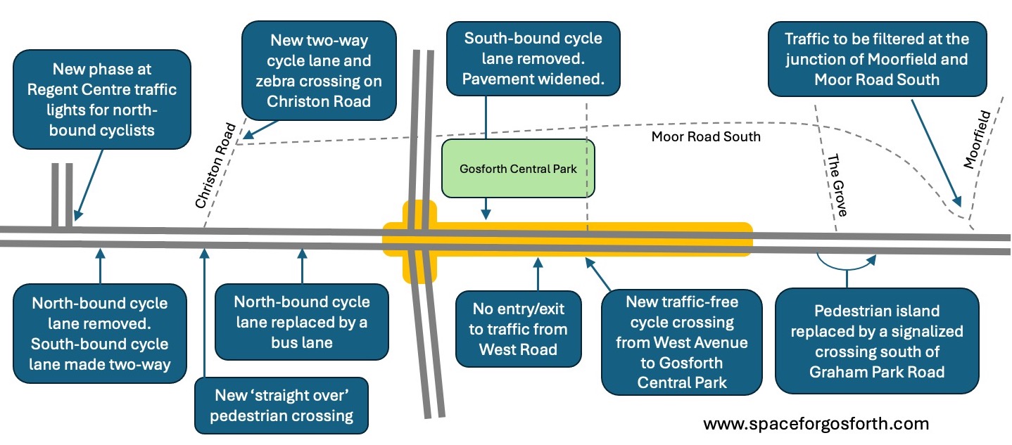
- A new cycling phase at Regent Centre traffic lights next to Gosforth Academy.
- The cycle lane along Christon Road to Gosforth Central Middle School, and parallel zebra crossing to Alwinton Road.
- A safe way for children and others to cross Gosforth High Street by West Avenue to access Gosforth Central Park.
We support wider pavement, where this can be achieved without putting other road users in danger, and improved crossings especially at the west end of Christon Road. Consideration should also be given to how businesses at the north end of Gosforth High Street receive deliveries.
We also support interventions at West Avenue and Moor Road South/Moorfield to reduce traffic levels in streets surrounding Gosforth High Street, which are currently subject to high levels of traffic often travelling in excess of the speed limit.
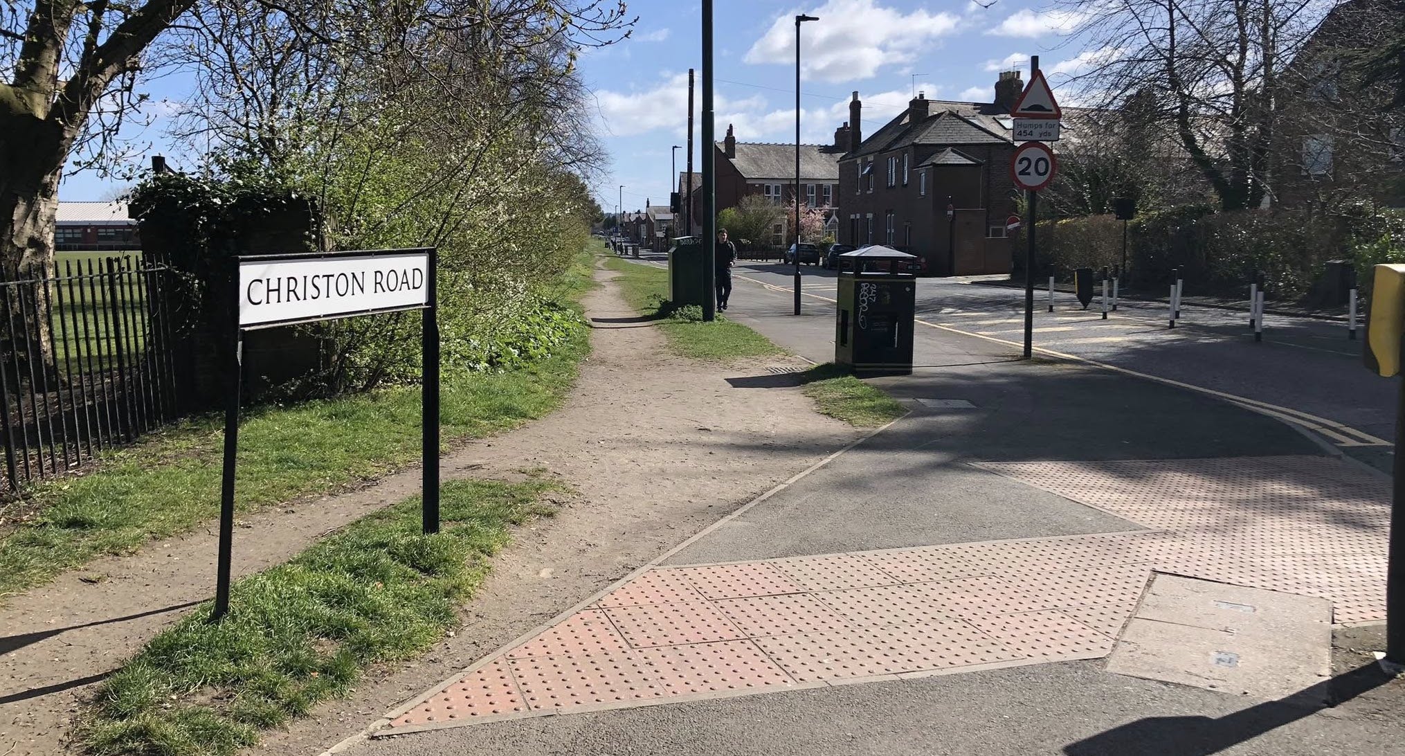
The location of the new cycle lane along Christon Road
2. What don’t we like about the proposals?
We don’t like that the Council continues to prioritise traffic travelling through Gosforth High Street over people travelling to, from and around Gosforth High Street. The benefits of this are a small time saving for bus passengers in the afternoon peak but the negatives, especially safety issues, lack of safe access to the shops for people cycling, and issues due to high traffic volumes are felt all day every day.
We don’t like the removal of the north-bound protected cycle lane between Salters Road and Regent Centre, which apart from anything else will mean there is no safe route to cycle from Henry Street to Gosforth Central Middle School. We understand from members that this route is also used by high school students travelling to Gosforth Academy.
We don’t like the removal of the well-used pedestrian crossing between Elmfield Road and The Grove.
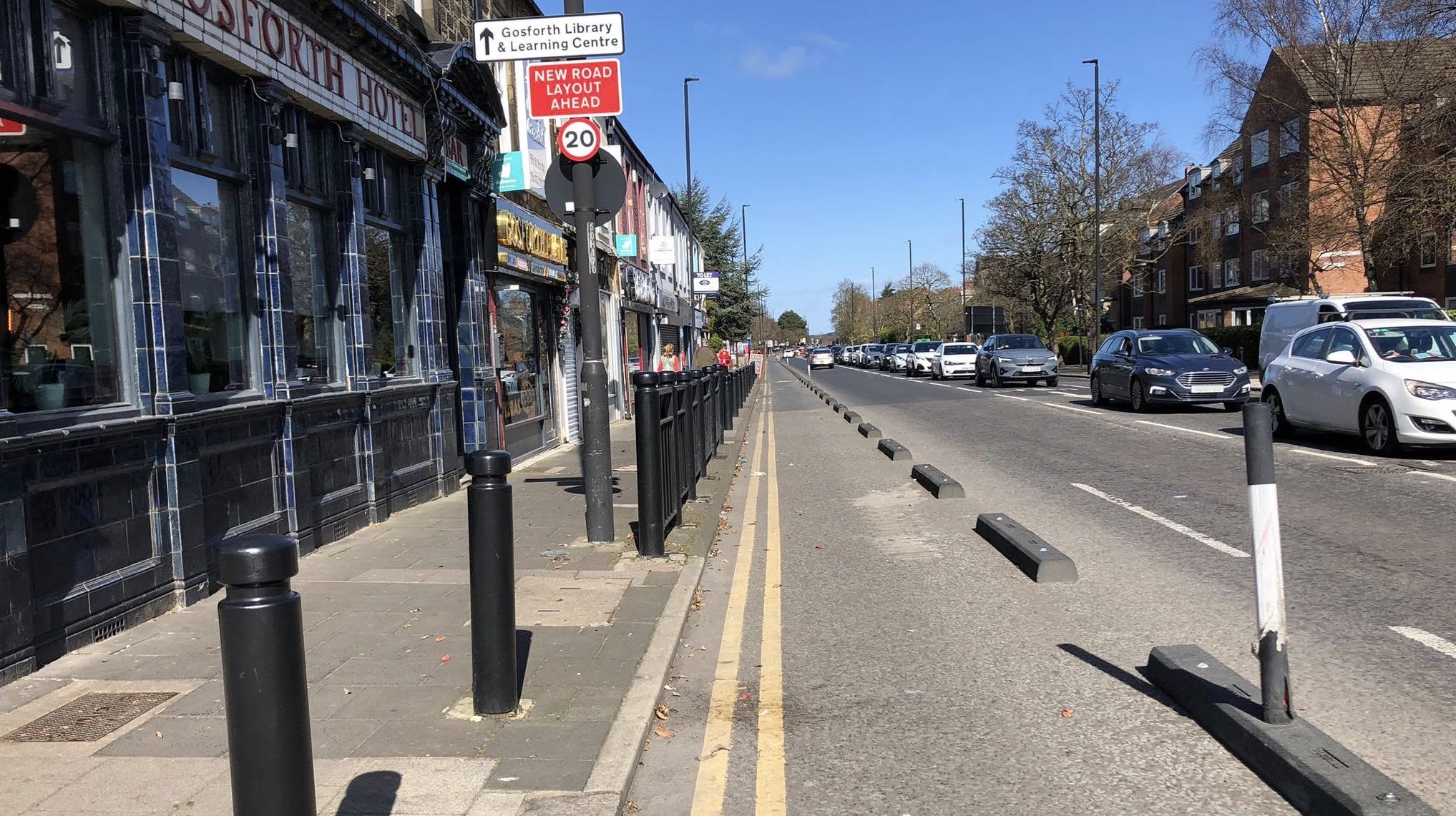
The protected cycle lane that Newcastle City Council proposes to remove.
3. Our ideas to improve the proposals
High traffic volumes are the main reason for delays to buses. To minimise delays, the Council should revamp its “strategy to divert traffic away from the High Street” referred to in paragraph 9.8 of the Bus Lane Delegated Decision Report, which currently consists of a sign on the A1.
In addition to reducing traffic levels, bus priority should be prioritised outside the shopping area where it is possible to do so without creating safety issues for other road users. Within the shopping area other priorities should apply, in particular public realm improvements and good quality and safe walking and cycling facilities. This mixed approach should still provide considerable benefit to bus users as Haymarket Bus Station to the A1 via Great North Road is approximately four miles, whereas the Gosforth High Street shops take up less than half a mile.
The Council should take a more holistic view of destinations, not just Gosforth Shopping Centre, the only ‘trip generator’ marked on the Council’s mapping. Other local destinations that should be accessible from the Great North Road cycle route include:
- Gosforth Library and Swimming Pool
- Gosforth Civic Theatre
- Gosforth Academy and Grange First School
- Regent Centre Metro
- Asda and Marks and Spencers
- Archbishop Runcie First School and Gosforth Central Middle School
- St Charles Primary School
- Gosforth East Middle School, Gosforth Park First School and St Oswalds Primary School
- Gosforth High Street shops north and south of Gosforth Shopping Centre
- Gosforth Central Park and the Hut on the Green
- Gosforth Junior Academy and Archibald First School
- Churches and church halls including Trinity Church, All Saints Church, Gosforth Parish Church and St Charles Catholic Church
- Private nurseries, playgroups and other children’s venues such as softplay
- Local sporting facilities including gyms, tennis clubs, and bowling clubs
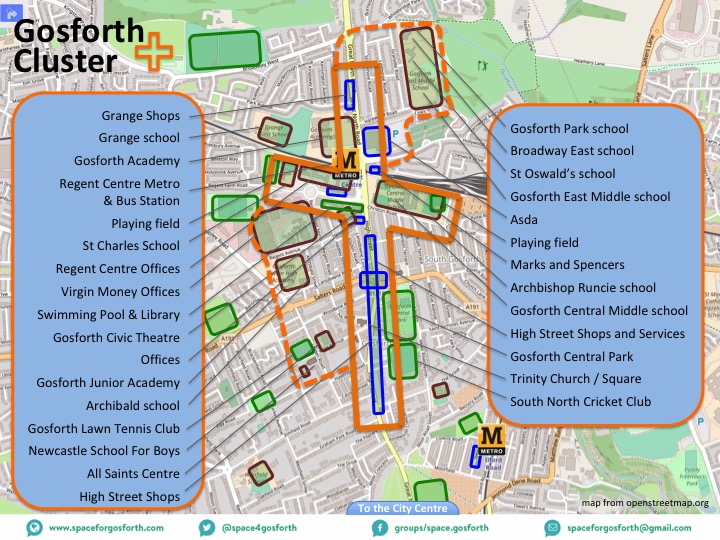
Local destinations in and around Gosforth High Street – diagram from 2018.
This would be consistent with the Council’s ambition “to introduce a walking, wheeling, and cycling network that connects every school, to every park, to every high street”
This is also important given the recent school adjudicator statement on Gosforth Academy admissions that stated that most academy students should be able to travel to school unaccompanied and for this reason students did not need to be in the same school as their siblings in order to facilitate being driven to school as a family group.
Other ideas to improve the proposals include:
- Extending the proposed Christon Road cycle lane to Archbishop Runcie First School and Rydal Road, with a filter to allow cycles to cross south to use Beaumont Terrace (to avoid traffic on Hyde Terrace).
- The proposed two-way cycle lane on the east side of Great North Road north of Christon Road could be extended south using space on the wide eastern pavement south of Christon Road. This would enable access to shops at the north end of Gosforth High Street.
- Redesigning the corner of Christon Road and Great North Road to avoid the need for shared pavement.
- Expanding the two-way cycle route on Gosforth High Street between St Nicholas Avenue and West Road to allow cycle access to Ivy Road and shops south of St Nicholas Avenue. Ideally this should extend south to Hawthorn Road so the bus lane/vehicle lane merge is by The County.
- Further safe cycle crossings e.g. from Elmfield to The Grove and Moorfield to Moor Crescent to prevent the route through Gosforth Central Park from getting too busy and providing an alternative crossing for use in dark evenings when some people may not wish to cycle through the park. On the Moorfield to Moor Crescent crossing this should avoid the use of shared pavement.
- An alternative to removing the pedestrian refuge north of the Grove would be to move the current crossing north of Elmfield Road to where the pedestrian refuge is now, making it a Toucan crossing to enable people to cross safely by bicycle between The Grove and Elmfield Road.
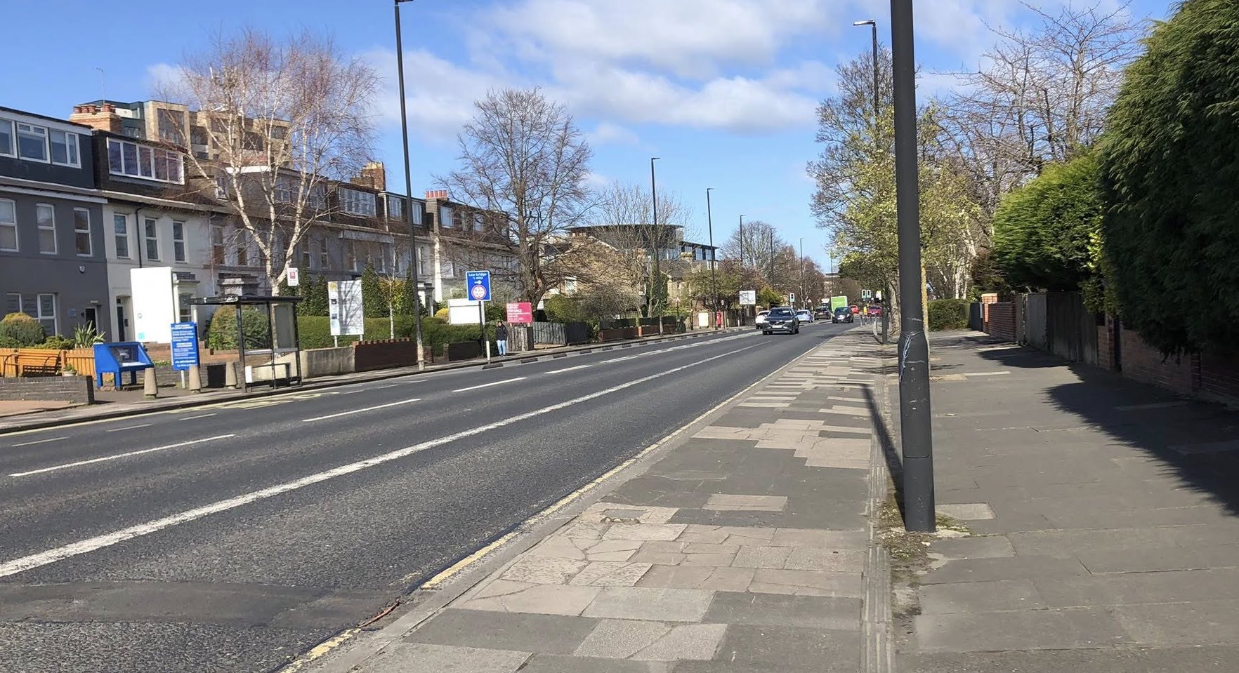
- Traffic volumes and speeds on Moor Road North and South exceed the limits set out in LTN1/20 for these roads to be suitable for all ages and abilities. Additional measures need to be installed to reduce traffic levels. One option might be north-bound only for vehicles at south end of Moor Road South.
Wide pavement that could be used to extend the two-way cycle lane south
Further ideas that could be incorporated are:
- Declutter the pavement and trial removing the black bollards which take up over half a metre of pavement space on each side.
- Reduce pedestrian crossing wait times, and ensure that there is sufficient time for people to cross.
- Look for opportunities to improve the pedestrian environment e.g. for street cafes, planting or benches, including at ends of side streets.
- Pedestrianise side street-ends so people walking along the High Street have priority over turning vehicles in line with the new Highway Code.
- Reduce non-local traffic using streets either side of the High Street, including Linden Road, Elmfield Road and The Grove, to make it safer and more pleasant for people to walk or cycle to Gosforth High Street.
- Re-allow the right turn southbound from Gosforth High Street to Salters Road to reduce traffic on Regent Road North.
- Extend the 20mph zone north past Gosforth Academy, west past Gosforth Junior Academy and south to the Little Moor.
- Removal of the left turn slip into Hollywood Avenue from Great North Road to reduce the risk of a ‘left hook’ collision caused by a vehicle turning left across the cycle lane.
- Implementation of a Regent Centre Active Travel Hub as we described in our response to the NE Local Transport Plan consultation.
- Install dropped kerbs on Moor Road South to make the pavement more accessible for wheelchair users.
- Other small changes set out in our blog Gosforth High Street – Small Changes.These included:
- Narrowing the exit to Elmfield Road.
- Installing Sheffield Stands between black bollards.
- Increasing the pavement space outside Gosforth Central Park.
- Trialling an implied Zebra crossing across the ramp to the Gosforth Shopping Centre car park.
- A dropped kerb at the entrance to Gosforth Central Park.
- Planting and a small tree in the Salters Road car park
- Moving the bench in the island next to Gosforth Hotel so it is not hidden behind a bush.
- Tightening the corners at The Grove to improve safety for people crossing the road.

Pavement on Moor Road south lacking a dropped kerb
4. Other Comments
In answer to a question at September 2024’s City Council the then Cabinet Lead for transport said “The Council is committed to ensuring the success of district centres and as we have set out, we are committed to improving road safety, creating better public transport links and encouraging active travel around the Gosforth High Street area” The Cabinet lead also committed that plans would include “features such as cycle parking and public realm improvements.”
This commitment should be set out in holistic plan setting out proposals to enable people to walk and cycle safely to Gosforth High Street from surrounding areas.
The plan should also set out how transport proposals will support businesses to attract customers. In particular:
- Improving Gosforth High Street as a destination (public realm); and
- Enabling more customers to travel to and from Gosforth High Street without adding to existing high levels of traffic or air pollution.
Our suggestions above will help to achieve these aims.
Connectivity to the local destinations listed above should be via a dense network of routes. As it says in LTN1/20, these routes should be “at least as direct – and preferably more direct – than those available for motor vehicles.” LTN1/20 also recommends a spacing of 250-400m between parallel routes, which suggests both Gosforth High Street and Moor Road should be made suitable for cycling.
Prioritising walking and cycling for local journeys is also essential if the Council is to achieve its aim – as presented by the Assistant Director for Transport at the 2024 Council Climate Summit – for 50% of local journeys to be made by walking or cycling by 2030.
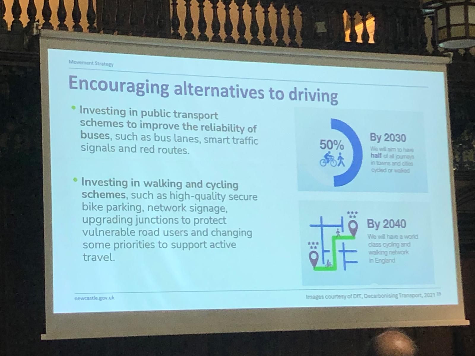
By 2030 we will aim to have half of all journeys in towns and cities cycled or walked – 2024 Council Climate Summit.
You can complete the Council survey on the Council’s Let’s Talk Website. The deadline is Sunday 27 April 2025.