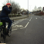
 Killingworth Road closes 20 July. SPACE for Gosforth and Bike4Health have arranged a Killi Road Bike Train to Quorum to help commuters from Fenham, Spital Tongues, Jesmond and Gosforth beat the traffic! Read more [...]
 Choo! Choo! Book your ticket for the Killi Road Bike Train 17-21 July!
Killingworth Road closes 20 July. SPACE for Gosforth and Bike4Health have arranged a Killi Road Bike Train to Quorum to help commuters from Fenham, Spital Tongues, Jesmond and Gosforth beat the traffic! Read more [...]  One of our members was so concerned about idling engines by his children's school - so he decided some education was needed!
  Blue House, Gosforth High Street, electric bikes, guest speakers and much much more - a year in the life of SPACE for Gosforth!
 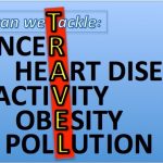 On 12 April, six days before the General Election was announced, the Evening Standard published an article quoting Theresa May stating that toxic air pollution is the fourth biggest public health risk behind cancer, obesity and heart disease.
While there are multiple causes for each of these public health risks,
we can dramatically reduce the impact of all these risks - and more -
by changing how we travel.
On 12 April, six days before the General Election was announced, the Evening Standard published an article quoting Theresa May stating that toxic air pollution is the fourth biggest public health risk behind cancer, obesity and heart disease.
While there are multiple causes for each of these public health risks,
we can dramatically reduce the impact of all these risks - and more -
by changing how we travel. 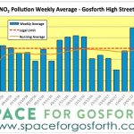 In previous posts we looked at air quality data on Gosforth High Street and on Jesmond Road in the run up to Christmas last year, which showed a marked increase in pollution after Black Friday, 25 November 2016. In this post we look at what has happened to air quality at these sites since then.
 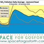 In this post we look at the City Centre Air Quality Management Area (AQMA), including equivalent figures from the air quality monitor sited at Jesmond Road, 150m west of the Osborne Avenue traffic lights, to see how this compares to Salters Road and whether the recent increase in air pollution is replicated there.
 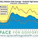 Since Black Friday, 25 November 2016, readings from the new air quality monitor at the Salters Road car park say the average level of nitrogen dioxide (NO2) has been 50.3 micrograms per cubic metre (μg/m3) or 26% above the legal limit. The legal limit is 40 μg/m3 averaged over a year. It was high levels of nitrogen dioxide that led to the creation of the South Gosforth Air Quality Management Area in 2008.
While air pollution is damaging to health, personal exposure travelling further
Since Black Friday, 25 November 2016, readings from the new air quality monitor at the Salters Road car park say the average level of nitrogen dioxide (NO2) has been 50.3 micrograms per cubic metre (μg/m3) or 26% above the legal limit. The legal limit is 40 μg/m3 averaged over a year. It was high levels of nitrogen dioxide that led to the creation of the South Gosforth Air Quality Management Area in 2008.
While air pollution is damaging to health, personal exposure travelling further 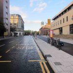 In this post we want to look at the new street layout on John Dobson Street, and whether it has improved the experience of those who use this street. The improvements are a flagship project for Newcastle upon Tyne City Council, with a new traffic-free cycle lane that links Newcastle Civic Centre at St. Mary's Place and the Blue Carpet in front of the Laing Art Gallery and the Journey (Newcastle's healthy travel centre) on New Bridge Street West.
1. Walking
The new cycle lane has
In this post we want to look at the new street layout on John Dobson Street, and whether it has improved the experience of those who use this street. The improvements are a flagship project for Newcastle upon Tyne City Council, with a new traffic-free cycle lane that links Newcastle Civic Centre at St. Mary's Place and the Blue Carpet in front of the Laing Art Gallery and the Journey (Newcastle's healthy travel centre) on New Bridge Street West.
1. Walking
The new cycle lane has  In this post we look at the Environmental Impact Assessment Screening & Scoping Report ("the EIASSR") lodged as part of the planning documents for the original plans for the Blue House roundabout and Jesmond Dene Road. The EIASSR's aim was to identify the different types of environmental assessments that would have been needed had those plans gone ahead.
 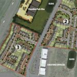 One of the reasons stated for the size of the proposed Blue House roundabout was extra traffic generated by new housing developments to the west and north of the city. Planning approval is currently being sought from North Tyneside Council for a development of 238 new houses on Gosforth Business Park. This development, and in particular decisions made relating to its layout and design, will directly influence the volume of traffic through Haddricks Mill and Blue House junctions.